


Pinson United Methodist Church, Jefferson County, Alabama
About
Outline

Summary
| Unique Area Identifier | 522155 |
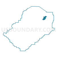
| Name | Pinson United Methodist Church |
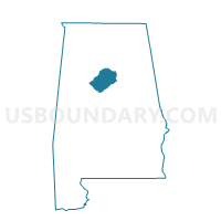
| County | Jefferson County |
| State | Alabama |
| Area (square miles) | 6.52 |
| Land Area (square miles) | 6.49 |
| Water Area (square miles) | 0.03 |
| % of Land Area | 99.58 |
| % of Water Area | 0.42 |
| Latitude of the Internal Point | 33.68746960 |
| Longtitude of the Internal Point | -86.67439440 |
Maps

Graphs
Select a template below for downloading or customizing gragh for Pinson United Methodist Church, Jefferson County, Alabama


Neighbors
Neighoring Voting District (by Name) Neighboring Voting District on the Map
- Center Point Courthouse Annex, Jefferson County, AL
- Clay Community Center, Jefferson County, AL
- Clearview Baptist Church, Jefferson County, AL
- Hilldale Baptist Church, Jefferson County, AL
- Jefferson State Junior College, Jefferson County, AL
- Kermit A Johnson Elementary School, Jefferson County, AL
- Palmerdale United Methodist Church, Jefferson County, AL
Top 10 Neighboring County Subdivision (by Population) Neighboring County Subdivision on the Map
- Birmingham CCD, Jefferson County, AL (455,278)
- Gardendale CCD, Jefferson County, AL (23,184)
- Clay CCD, Jefferson County, AL (13,695)
- Kimberly-Morris CCD, Jefferson County, AL (9,888)
- Palmerdale CCD, Jefferson County, AL (5,686)
Top 10 Neighboring Place (by Population) Neighboring Place on the Map
Top 10 Neighboring Unified School District (by Population) Neighboring Unified School District on the Map
Top 10 Neighboring State Legislative District Lower Chamber (by Population) Neighboring State Legislative District Lower Chamber on the Map
Top 10 Neighboring State Legislative District Upper Chamber (by Population) Neighboring State Legislative District Upper Chamber on the Map
- State Senate District 15, AL (160,461)
- State Senate District 17, AL (157,178)
- State Senate District 20, AL (107,375)
Top 10 Neighboring 111th Congressional District (by Population) Neighboring 111th Congressional District on the Map
Top 10 Neighboring Census Tract (by Population) Neighboring Census Tract on the Map
- Census Tract 112.06, Jefferson County, AL (5,686)
- Census Tract 111.10, Jefferson County, AL (5,677)
- Census Tract 112.07, Jefferson County, AL (5,010)
- Census Tract 112.08, Jefferson County, AL (3,975)
- Census Tract 112.10, Jefferson County, AL (3,820)
- Census Tract 113.01, Jefferson County, AL (3,621)
- Census Tract 112.09, Jefferson County, AL (3,221)
- Census Tract 117.06, Jefferson County, AL (2,394)
- Census Tract 112.05, Jefferson County, AL (2,087)